Mt. Talinis/Bediao-Apolong Traverse to Casaroro Falls (1,903+)


MT. TALINIS (BEDIAO-APOLONG TRAVERSE)
Dauin and Valencia City, Negros Oriental
Entry point: Brgy. Bediao, Dauin
Exit point: Brgy. Apolong, Valencia City
LLA: 1903 MASL
Days required / Hours to summit: 2-3 days / 10-11 hours
Specs: Major climb, Difficulty 6/9, Trail class 2-4
Features: Lakes, waterfalls, mossy forest
BACKGROUND
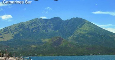
A longtime favorite Visayan destination of mountaineers is Mt. Talinis in Southern Negros, otherwise known as “Cuernos de Negros” for the horn-like peaks that highlight the mountain. It holds its position as the second highest mountain in Negros, next only to the lofty Kanlaon.
It is not surprising that Talinis is the only mountain other than Mt. Apo to have become twice the venue of the annual MFPI Federation climbs, among other activities. Its only impediment is the perennial rumor of NPA presence, but as of 2009, it is perfectly safe to climb Talinis.
There are several trails but the most typical, and comprehensive enough, route is a traverse from the Bediao trail in Dauin, Negros Oriental, to Apolong. The roster of places to see is formidable: first is Lake Yagumyum with the optional ascent to Yagumyum Peak; then, passing by the mystical maribuhok forests, one reaches the higher and grander Lake Nailig. From this lagoon there is again the option to scale Nailig Peak, otherwise known as Talinis Dako i.e. the highest point in the mountain. Finally, on the way down via the Apolong Route, pass by the sulphuric river and the Twin Falls of Talinis before ending in the grand cascade of Casaroro Falls, the highest in Negros at over 90 meters. A destination by itself, Casaroro Falls is a fitting conclusion to the Talinis experience.
ITINERARY
Bediao-Apolong route from Dumaguete City
Day 1
0600 From Dumaguete, take Ceres minibus to Dauin
0700 Get off at plaza; arrange habal-habal to Geothermal Site, Bediao
0730 ETA jumpoff. Start trek
1200 ETA Lake Yagumgyum. 30-minute assault to Yagumyum Peak
1330 Back at Lake Yagumyum, proceed to Lake Nailig
1700 ETA Lake Nailig; set up camp
1800 Dinner / socials
Day 2
0500 Talinis summit assault
0700 ETA summit
0730 Head back to Nailig campsite
0900 Start descent
1200 ETA Sulfuric River
1500 ETA Casaroro Falls; sidetrip
1900 Back in Dumaguete
NOTE: the two peaks can be discarded for a lighter itinerary. Also, this same itinerary can be spread over three days.
SPECIAL CONCERNS
Mt. Talinis is one of the remaining mountains under the care of a local mountaineering club, in keeping with old mountaineering tradition. The Cuernos de Negros Mountaineers, Inc. (CNMCI) based in Siliman University, Dumaguete, has maintained a close and fruitful relationship with the mountain and they are the best contact when planning a Talinis climb.
Transportation. To go to Talinis, the staging-off point is Dumaguete City. There are at least a few flights daily. Fares range from 3000-6000 roundtrip. Or, take the six-hour trip from Bacolod to Dumaguete (~P180). From Dumaguete take a tricycle to the Ceres bus terminal and take the minibus to Dauin. From Dauin municipality take a habal-habal up the mountain to the jumpoff in Bediao Geothermal Site. At the other end – you can take a habal-habal from the Casaroro Falls junction to Valencia town proper, where jeepneys will take you back to Dumaguete. Here don’t fail to appreciate a nice view of Talinis.
Climbing notes. It is safe to swim on both lakes Yagumyum and Nailig although the latter is cleaner albeit colder. You can also swim in the pools of Casaroro Falls. Cellphone signal is sporadic on the trail but it is present in the Maribuhok-Nailig leg of the trail. Water sources are available in the two lakes as well.
PICTURES OF MT. TALINIS AND CASARORO FALLS

The start of the trail is an exposed slope, lending an expansive view of the southern Visayan seas.

Behold the tranquility of Lake Yagumyum, the first ancient crater lake to be encountered in the trek.

Between the two lakes stands a ridge of grand, mossy, ancient maribuhok trees.

Lake Nailig is the setting of one of the most scenic and cold campsites in the Visayas.

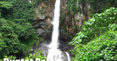
The finale of the traverse is swimming and sightseeing in the realm of Casaroro Falls, the tallest waterfalls in the Visayas.
TRIVIA
Beside Lake Nailig is another lake called Lake Mabilog. It has a pecuiliar rounded shape and is said to be the hideout of snakes.
Mt. Talinis is the third mountain in the Visayan Voyage. A narrative of the blogger’s trip to Talinis will be published in Manila Bulletin on July 25, 2009.
PinoyMountaineer thanks the Cuernos de Negros Mountaineering Club, Inc. for hosting the blogger and the Visayan Voyage Team in Mt. Talinis on April 9-10, 2009. Images courtesy of Lalaine Hablado, Julian Canero, and Jacob Sarreal.
You May Also Like
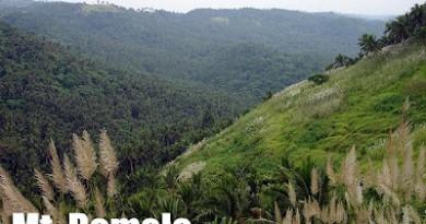
Mt. Asog (1,140+)
ake in Dumaguete, Philippines
Balanan Lake Photo © Travelling the Philippines
Balanan Lake
Lake Balanan is a freshwater lake surrounded by lush tropical rainforest with the mountain ranges of
Balanan in the East, and Nasig-id in the West. This placid lake is located in Sitio Balanan,
Barangay Sandulot in the municipality of Siaton, Negros Oriental  , about 55 kilometers south of
Dumaguete City. Lodged deep in the mountains, the lake is primarily fed by the Lamarao
Creek, Balanan Creek, and Nasig-id Creek, and flows out to Balanan River.
, about 55 kilometers south of
Dumaguete City. Lodged deep in the mountains, the lake is primarily fed by the Lamarao
Creek, Balanan Creek, and Nasig-id Creek, and flows out to Balanan River.History
Lake Balanan was formed in 1925 when an earthquake with a 6.8 magnitude on the Richter scale caused massive landslides in both mountain ranges. The landslide created a natural dam right across the southern end of the Balanan River and the water rose to become a figure 8-shaped lake.People then started living along its banks. The local government developed the area as a tourist attraction in the early 1990s which generated jobs for these villagers. In 2007, the Balanan Lake Development Authority was created to oversee the development and management of the lake and watershed area.
Visiting the Lake
The magnificent views of the mountains, forest, and lake is worth the long drive to Lake Balanan. The drive is a 10-kilometer uphill route that is exciting as well as scary for some because certain parts of the journey passes by the edge of the cliff which are not protected by railings. However, you will see beautiful, natural scenery along the way that will keep you occupied.The whole lake covers a total surface area of 24 hectares. The size of the lake makes it a great playground for activities like boating and kayaking. Swimming is prohibited in the lake itself but if you insist, the staff will let you sign a waiver stating that you take full responsibility for swimming despite the warnings.
With an elevation of 285 meters above sea level, its cool mountain air and the serene ambiance where only the sounds of nature dominate makes this an ideal retreat to unwind and rejuvenate. The lush rainforest is home to different plant species including more than 100 old Giant Balete trees. A variety of waterfowl have been sighted in the lush tropical rainforest that surrounds the lake including Egrets, Ducks, Herons, Gallinules, and Rails. There are colonies of bats and other wildlife that must be preserved and there is a proposal to protect the area as a Game Refuge and Wildlife Sanctuary.
Mountain Resort
In recent years, Lake Balanan was developed into a mountain resort that offers different accommodations and a variety of outdoor activities. Some of the amenities in the resort include the Balanan Hillside Pools, a set of four natural swimming pools carved out from the hills. Just imagine the excitement of sitting on the pool’s edge that is situated at the edge of a cliff overlooking lush vegetation. Other amenities include a gourmet restaurant, a treehouse, rooms, and cottages that are available for overnight stays.While it is extremely relaxing to just sit down, relax, and stare at the lake’s placid waters, the more adventurous guests can opt to go to the zip-line, kayaking, fishing, trekking, and hiking on concrete pathways that wind around the lake. Taking a dip in Balanan Waterfalls is refreshing and invigorating at the same time. During the weekends, the place host many families who come here to have picnics in the cottages and swim in the pools.
Entrance to the lake and resort is ₱ 50 for adults and ₱ 30 for kids 12 years old and below. Entrance is free on Tuesday and for those staying overnight in the resort's cottages. These are the rates for the use of the different facilities and amenities:
- 3 Swimming Pools – Free of charge
- Kayak – ₱ 150 per hour for 2 persons
- Triak – ₱ 200 per hour for 3 persons
- Pedal Boat – ₱ 100 per hour
- Banca (Small Boat) Tour – ₱ 50 per hour for 2 persons; ₱ 100 per hour for big groups
- Zip Line – ₱ 150 for sitting position and ₱ 200 for superman position
- Floating Cottage – ₱ 100 per day
- Picnic Table – ₱ 30 per day
- Camping fee – ₱ 150
Those planning to stay overnight can stay at the resort hotel and cottages:
- Small Room – ₱ 1,500 per day for 3 persons; ₱ 200 per extra person
- Large Room – ₱ 4,000 per day for 4 persons; ₱ 200 per extra person
- Staff House – ₱ 2,000 per day for 10 persons; ₱ 100 per extra person up to 5
- Tree House – ₱ 2,000 per day for 6 persons
How to Get There
Public Transportation
Take a Ceres bus for Siaton or Bayawan City at
the Ceres bus terminal located in Calindagan, Dumaguete City near Robinson’s Place Dumaguete. The municipality of Siaton is 55 kilometers
or 1.5 hours away from Dumaguete, and the bus fare is ₱ 60 . But get off at the highway junction at the end of
Siaton Bridge or at Kilometer 51 where there are motorcycles and habal-habals for hire, or get off
right at the Siaton Church where the habal-habal terminal for Balanan is situated. They charge ₱ 50 to
₱ 100 for the 30-minute ride to the lake, depending on your negotiating skills.Private Vehicle for Hire
The most comfortable and convenient, albeit more expensive way to go to Lake Balanan is to hire a private van or pick-up to take you all the way from Dumaguete City to the lake. You just need to inform them that you want to go to Lake Balanan and let them take care of the rest. Rates start at ₱ 3,000 for 1 day depending on the vehicle to be used.Safety
For your own safety, it is best to obey the rules which state that there is no swimming at the lake. There have been incidents of drowning in the past.Travel Tips
If you are taking a habal-habal to the resort, negotiate with the driver for a round-trip fare. Ask for his mobile number so you can call or text him when you are ready to be picked up. There is signal at the resort although it is weak at only 1 to 2 bar reception.Try to schedule your trip during summer or on non-rainy days so you can go kayaking or boating to the Balanan Waterfalls. However, if you seek peace and quiet, the weekdays and rainy days are the perfect time to go.
Do you see any omissions, errors or want to add information to this page? Sign up.
Author: janblim. Last updated: Nov 14, 2014
Pictures of Balanan Lake


No comments:
Post a Comment